ACTIVITIES

TOPACTIVITIESIPSI Collaborative ActivitiesSystem-of-Systems Solution in Monitoring, Reporting, Validation, and Verification on GHGs/Carbon Cyc...
System-of-Systems Solution in Monitoring, Reporting, Validation, and Verification on GHGs/Carbon Cycle in Biodiversity Ecosystem for SEPLS to Strengthen Sustainable Frameworks Development
Lead organization: SEPLS Carbon Credit Regional Revitalization Center (Seed Coleus Greenhouse) and Taiwan Space Agency (TASA)
Other participating organizations: Agency of Rural Development and Soil and Water Conservation; Northwestern University; University of Toronto; Research Center for Applied Sciences, Academia Sinica (RCAS); National Cheng Kung University; National Taiwan University; NCKU Research & Development Foundation
Background
From the Paris Agreement, the Kyoto Protocol and the Convention, the climate actions determine whether the world achieves the long-term goals of the Paris Agreement and to reach global peaking of greenhouse gas (GHG) emissions as soon as possible and to undertake rapid reductions thereafter in accordance with best available science, so as to achieve a balance between anthropogenic emissions by sources and removals by sinks of GHGs. At the same time, the climate actions align with the spirit of the Satoyama Initiative and the Kunming-Montreal Global Biodiversity Framework. Biodiversity is fundamental to human well-being, a healthy planet, and economic prosperity for all people, including for living well in balance and in harmony with Mother Earth. The Kunming-Montreal Global Biodiversity Framework is a global agreement of the 15th Conference of the Parties to the Convention on Biological Diversity (CBD COP15). The Kunming-Montreal Global Biodiversity Framework has four long-term goals for 2050 related to the 2050 Vision for biodiversity. The four long-term goals include GOAL A: Protect and Restore, GOAL B: Prosper with Nature, GOAL C: Share Benefits Fairly, and GOAL D: Invest and Collaborate. Most area consist mostly of multifunctional landscapes and seascapes, and their coastal waters consist mostly of multifunctional seascapes. These landscapes and seascapes may cross national and other boundaries. That’s too much for the operator to manage, so landscape approaches cannot be applied everywhere, immediately.
Actions of monitoring the Geographic Information System to reach these targets should be implemented consistently and in harmony with the Convention on Biological Diversity and its Protocols and other relevant international obligations, taking into account national circumstances, priorities, and socioeconomic conditions. Recognition of the efforts of local proponents of landscape approaches can encourage them to continue and to expand their efforts and can serve as a model for others by the model of carbon credit program. SEPLS carbon credit regional revitalization approaches are tools and solutions for implementation and mainstreaming. SEPLS carbon credit regional revitalization approaches in carbon credit programs not only reduce threats to biodiversity but also meet people’s needs through sustainable use and benefit-sharing by designing and shaping the implementation, corresponding to Kunming-Montreal Global Biodiversity Framework (KMGBF).
By this way, Action 2023-2030 in the strategy and plan:
- Knowledge Co-Production, Management, and Uptake: Conduct research and knowledge management related to landscape and seascape approaches to address direct and underlying causes responsible for the loss of biological and cultural diversity as well as ecological and socio-economic services in carbon credit from SEPLS.
- Institutional Frameworks and Capacity Development: Strengthen institutional frameworks and develop capacity to integrate landscape and seascape approaches into policies and cross-sectoral strategies related to biodiversity, climate change, sustainable land and sea management, health, agri-food systems, and disaster risk reduction to maintain or enhance the benefits of SEPLS in carbon credit to the environment and society.
- Area-Based Conservation Measures: Promote effective conservation and management through protected areas and other effective area-based conservation measures (OECMs), recognizing indigenous and traditional territories where applicable, and facilitate their integration in carbon credit into the wider landscape and seascape to contribute to the relevant targets of the Kunming-Montreal Global Biodiversity Framework.
- Ecosystem Restoration: Promote the restoration of SEPLS by deriving carbon credit and contribute to the goals of the United Nations Decade on Ecosystem Restoration and relevant targets of the Kunming-Montreal Global Biodiversity Framework.
- Sustainable Value Chain Development: Promote sustainable practices, market-based mechanisms, and value chains to support sustainable production, including customary sustainable use and economies in carbon credit that rely on traditional knowledge and cultural values and practices, from SEPLS to contribute to the achievement of relevant targets of the Kunming-Montreal Global Biodiversity Framework.
Biodiversity carbon reduction technologies offer several benefits for local communities, including:
- Enhanced Ecosystem Services: These technologies help in restoring and maintaining ecosystems, which provide essential services such as clean water, air purification, and soil fertility. Healthy ecosystems contribute to better agricultural productivity and food security.
- Climate Resilience: By promoting biodiversity, these technologies can enhance the resilience of local communities to climate change impacts. Diverse ecosystems are better able to withstand environmental stresses and recover from disturbances.
- Economic Opportunities: Implementing carbon reduction technologies can create new job opportunities in areas such as sustainable agriculture, ecotourism, and conservation. Local communities can benefit from initiatives that promote sustainable practices and generate income.
- Community Engagement and Empowerment: Involving local communities in biodiversity conservation and carbon reduction efforts fosters a sense of ownership and responsibility. This engagement can strengthen community ties and promote collaborative efforts for environmental stewardship.
- Cultural and Social Benefits: Biodiversity is often linked to cultural identity and heritage. Protecting and enhancing local ecosystems can help preserve traditional knowledge, practices, and cultural landscapes, contributing to community well-being.
- Improved Health Outcomes: Cleaner environments resulting from healthy ecosystems can lead to better public health outcomes. Reduced pollution and enhanced natural spaces promote physical and mental well-being.
- Access to Funding and Resources: Participation in biodiversity carbon reduction initiatives can provide local communities with access to funding from governmental and non-governmental organizations focused on climate action and conservation.
- Sustainable Resource Management: These technologies encourage the sustainable use of natural resources, reducing overexploitation and ensuring that resources are available for future generations.
Biodiversity carbon reduction technologies contribute to environmental sustainability and support local communities’ socio-economic development.
A foundational and scalable framework to quantify field-level carbon outcomes for farmland, which is based on the holistic carbon balance of the agroecosystem: Agroecosystem Carbon Outcomes = Environment (E) × Management (M) × Crop (C). (Ref: Earth-Science Reviews 243, 104462 (2023)) When the referred aspect considers the ecosystem, the quantification of field-level carbon outcomes can be sit on the holistic carbon balance of the ecosystem: Ecosystem Carbon Outcomes = Environment (E) × Management (M) × Chloroplastida (C). In terms of Management (M), incorporating GBF and the IPSI Strategy and IPSI Plan of Action into management actions will enable a more effective achievement of the GBF 2050 goals and the UNFCCC 2050 goals.
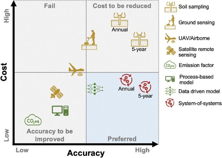
Different technological solutions for quantifying field-level carbon outcomes have many advantages and disadvantages (as shown in the following illustration). An integration of a more viable path, including sampling, sensing, and modeling is a novel aspect for quantification of field-level carbon outcomes, called “System-of-Systems” solution. The integration of a more viable path is also excellent tool for quantification of field-level monitor for climate change issues on all targeted fields for SEPLS to strengthen sustainable value chain development.
The integration with the accurate simulation results of different GHGs and organic carbon in the NIR range to NIR identification within the frame of the above-mentioned system can become a milestone to understand organic carbon, CO2, CH4, and N2O in the carbon cycle, which can save more sampling time and cost. By establishing the correlation between organic carbon changes and CO2, CH4, and N2O, we can also accurately calculate the dynamic exchange/release/storage status of CO2, CH4, and N2O. Therefore, we introduce a system of systems frame based on the AI data-driven: simulation/sampling/satellite.
Furthermore, UNEP recently proposed that wetlands (including wetlands, aquatic plants, coral reefs, and mangroves) have the largest carbon storage capacity. Satellite technology remote sensing can make up for the difficulties in sampling. However, in satellite technology, if NIR is used, it has high reflectivity at the water/air interface and low penetration in the water body. In recent years, microwave remote sensing technology has also been developed. L-band microwave (300-150 mm wavelength) radiometry can be used to observe the physical changes of surface plants and water bodies. Active or passive microwave remote sensing is used to indirectly estimate the total organic carbon (Soil Organic Carbon, SOC) in the soil and the dynamics of organic carbon below the surface of the water body or under the phytoplankton layer, using the indirect physical response of microwave signals to make inferences. The microwave monitoring range covers P, L, S, and C bands (1300 mm- 300 mm, 300-150 mm, 150-75 mm, and 75-37.5 mm in wavelength). If the GHGs and organic carbon spectrum simulation and satellite telemetry information in the microwave band can be further considered, the accuracy can be improved, and the original measurement of yellow carbon (soil carbon sink) can be extended to plant carbon sink (green carbon) and water carbon sink (blue carbon).
In this activity, we will combine AI, simulation, sampling, and satellite technology as a system of systems. In the AI technology, a generative reinforcement learning (GRL) model (a sophisticated extension of the reinforcement learning tool) is utilized. In the simulation, molecular spectra of GHGs and organic carbon molecules from the NIR to microwave range are provided to increase the robustness of the data. Simulation results are combined with satellite telemetry results, on-site sampling and analysis results to build a carbon sink database for Asia-Pacific region.
Activities
The Satoyama Mace Initiative (https://satoyamainitiative.org/activities/ipsi-collaborative-activities/satoyama-mace-initiative-regional-revitalization-of-sepls-in-carbon-credit/) is a transnational international project endorsed to be implemented by the UNU-IAS/IPSI in 2024. The biodiversity-based carbon credits certified from Satoyama Mace Initiative are designed to be:
- Additionality
Emission reductions or removals must occur because of the existence of the carbon credit market. Reductions that are only complying with legal or regulatory requirements are not eligible. Additionality must be clearly demonstrated using an approved methodology and verified by a third-party auditor.
- Baseline
A scientifically reasonable “business-as-usual” scenario must be established as a comparison. The baseline must be transparent, verifiable, and not overestimated.
- Real, Measurable, and Verifiable
Reductions must be quantifiable in tCO₂e. Projects must implement an MRV system (Monitoring, Reporting, Verification). Verification must be conducted by an independent third-party Verified/Validation Body (VVB).
- Permanence
Reductions or removals must be long-lasting and protected against reversal (e.g., forest fires). High-risk projects (such as forestry) must establish buffer pools or other risk mitigation mechanisms.
- No Double Counting
Credits cannot be double counted. Corresponding adjustments must be applied to ensure emission reductions are counted only once. Credits must be registered in a single, transparent registry to avoid duplication.
- Social and Environmental Safeguards
Projects must avoid major negative social or environmental impacts. Must respect Indigenous peoples’ and community rights (FPIC – Free, Prior, Informed Consent). Projects should contribute positively to biodiversity and sustainable development.
- Transparency
Project design documents (PDD), verification reports, and issuance records must be publicly accessible. Methodologies and standards used must be clearly specified and transparent.
The certified biodiversity-based carbon credits from Satoyama Mace Initiative are already listed on the international carbon exchanges. SEPLS Carbon Credit Regional Revitalization Center and Taiwan Space Agency (TASA), working with IPSI members and stakeholder representatives in this process, serve as a workstation to merge the Satoyama Initiative, KMGBF, and climate actions in the application of landscape approaches to National Biodiversity Strategies and Action Plans (NBSAPs), United Nations Framework Convention on Climate Change (UNFCCC), and United Nations Convention to Combat Desertification (UNCCD). Methodologies and on-site activities of biodiversity carbon credit are developed by SEPLS Carbon Credit Regional Revitalization Center and IPSIs.
Simulation results contributed by Prof. George Schatz (a theoretical chemist in the fields of reaction dynamics and nanotechnology, at Northwestern University) serves as the pilot to integrate satellite telemetry results, on-site sampling, and analysis results to set up modules/protocols and build a carbon sink database for the Asia-Pacific region. The integration of simulation, sampling, sensing, and modeling to form a system of systems for quantification of field-level monitoring for climate change issues on all targeted fields for SEPLS is to strengthen sustainable value chain development.
Actors and task sharing
Lead organization: SEPLS Carbon Credit Regional Revitalization Center and Taiwan Space Agency (TASA)
Organizations to work in science and technology: Northwestern University, University of Toronto, Research Center for Applied Sciences, Academia Sinica (RCAS); National Cheng Kung University, National Taiwan University; NCKU Research & Development Foundation; Agency of Rural Development and Soil and Water Conservation;
Other participants:
Other qualified IPSI members interested in the Satoyama Initiative, KMGBF, and climate actions in applying the above approaches to United Nations Framework Convention on Climate Change (UNFCCC), UN Convention to Combat Desertification (UNCCD), National Biodiversity Strategies and Action Plans (NBSAPs) and Community Development and Knowledge Management for the Satoyama Initiative (COMDEKS), and others.
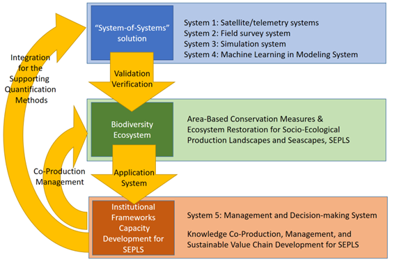
The complex problem of quantifying environmental factors in an ecosystem cannot be solved by using a single sensor or a model alone. The complex problem can only be solved by effectively integrating various approaches. TASA supports satellite remote sensing (System 1: Satellite/telemetry systems). SEPLS Carbon Credit Regional Revitalization Center and IPSIs cooperate with IPSI members and stakeholder representatives in System 2: Field survey system to provide sampling, ground sensing, and airborne. Prof. George Schatz’s group supports spectrum simulation of GHGs and organic carbon in the NIR and microwave regions. (System 3: Simulation system) SEPLS Carbon Credit Regional Revitalization Center also works with the Research Center for Applied Sciences, Academia Sinica (RCAS) in a process-based model and data driven model (System 4: Machine Learning Modeling System). The above integration, as the “cross-scale sensing” approaches, reaches the goal of quantification of field-level monitoring for climate change issues to be applied in System 5: Management and Decision-making System.
Sample design example for forest soil organic carbon (SOC) & mangrove water TOC (total organic carbon):
1 Sample number setting
1.1.1 Forest SOC
- Set up at least 3 to 5 sampling points for every 10 hectares
- Samples must cover different terrains (ridges, slopes, valleys)
- Stratified sampling: random sampling after grouping by NDVI or vegetation type
1.1.2 Mangrove TOC
- One sampling point is set every 500 meters in each waterway
- Contains different flooding frequency areas in the intertidal zone (high frequency flooding, medium frequency, low frequency)
- Stratified sampling: Sampling is divided into layers according to NDWI, water depth, and salinity gradient
2 Sample Design Process
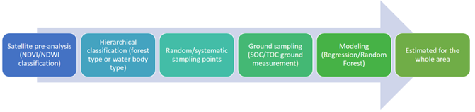
- Add system to systems design
3.1 Upstream systems (System 1: Satellite/telemetry systems)
- SMAP Microwave
- MODIS vegetation index
- Sentinel-1 SAR
- Sentinel-2 Water Color/Vegetation
Provides large-scale background fields (forest/water body spatial heterogeneity)
3.2 Ground system (System 2: Field survey system)
- Soil carbon measurement
- Dissolved carbon measurement in water
- Environmental conditions records
Provide basic point data as a basis for model training/verification
3.3 Theoretical system (System 3: Simulation system)
- Soil carbon and GHGs simulation in NIR
- Soil carbon and GHGs simulation in Microwave
- Soil carbon and GHGs simulation in spectrum
Provide basic point data as a basis for model training/verification
3.4 Estimation System (System 4: Machine Learning Modeling System)
- generative AI 2.0 model
- reinforcement learning model
- Deep Learning
Build a regional estimation model by linking system 1, system 2, and system 3 data
3.5 Application System (System 5: Management and Decision-making System)
- SOC/TOC map generation
- Identification of hotspots (high carbon and low carbon areas)
- Long-term change monitoring
The results support forest carbon sink assessment, water ecological management, and carbon rights market application in biodiversity.
Outcomes includes but not limited as the follows.
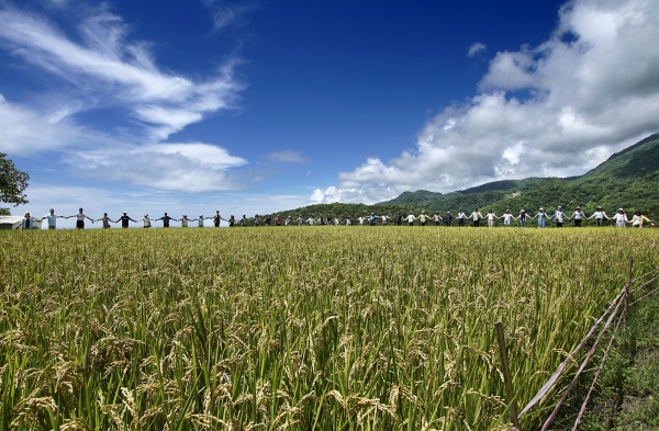
- On-site actions: on-site activities for the fusion according to the Satoyama Initiative, KMGBF, and climate actions in applying landscape approaches to National Biodiversity Strategies and Action Plans (NBSAPs). These activities aim to promote and support socio-ecological production landscapes and seascapes (SEPLS), contributing to the enhancement of biodiversity and the well-being of the local community. Furthermore, the parameters associated with carbon emission reduction, focusing on resource utilization, the cyclic use of natural resources, sustainable multi-functional management of natural resources and ecosystem services, as well as the development of sustainable socio-economies for physical/digital products enhance community resilience through ecosystem-based approaches for climate change mitigation and adaptation activities in multifunctional landscapes and seascapes.
- Partnership building: the establishment of multi-stakeholder platforms among local communities /indigenous peoples, governments, the private sector, and civil society to link communities of practitioners and share experiences.
- Research: the peer-reviewed paper & book publications. The research includes a baseline or evidence base for the actions of SEPLS management. Setup modules/protocols and build a carbon sink database for the Asia-Pacific region to local communities /indigenous peoples, governments, the private sector, and civil society.
- Education: Textbook development for technology application for SEPLS. The arrangement of the education venues (places) established for the field schooling to practice conduct seminars, workshops, courses, training classes, games, and other services from time to time. The e-learning alternative education programs to expand service areas in remote learning and replace in-person communication with online learning.
These carbon credits in biodiversity can be monetized in the sustainable value chain development, providing projects with financial support to scale up, enhance the 5 Ps of the 2030 Agenda: People, Prosperity, Planet, Peace, and Partnerships, and support the achievement of the KMGBF and UNFCCC 2050 goals.
Expected outcomes
- Designing an adaptive and evolutionary platform that empowers Indigenous peoples to receive biodiversity carbon credits while continuing their vital role in environmental stewardship.
- Co-research, set up modules/protocols, and build a carbon sink database for the Asia-Pacific region in monitoring, validation, and verification in biodiversity ecosystems.
- Share biodiversity carbon credit methodologies and database for potential joint pilot projects
- Support regional partners or governments in GHG program design and carbon credit registration/issue
- Partnership building in exchange for International mobility and MOUs.
- Host workshops or conferences to share experiences with IPSI members, local communities /indigenous peoples, governments, the private sector, and civil society.
- Enhanced knowledge and practices in area-based conservation measures and ecosystem restoration for SEPLS in sustainable value chain development for landscape approaches to National Biodiversity Strategies and Action Plans (NBSAPs).
- Strengthened institutional capacities in SEPLS management by publishing guide manual and handbook.
- Knowledge co-production, management, and uptake for SEPLS in on-site activity, field house, and education.
- Sustainable livelihoods and economic opportunities for Sustainable Value Chain Development for SEPLS by GHG program to get carbon credit to exchange in climate actions markets.
- All of the above with special reference to the NBSAPs, United Nations Framework Convention on Climate Change (UNFCCC), and United Nations Convention to Combat Desertification (UNCCD).
How the activity relates to the IPSI Strategy and Action Plan
The effective integration among various approaches builds up a system-of-systems solution which includes upstream systems (System 1: satellite/telemetry systems), ground system (System 2: field survey system), theoretical system (System 3: Simulation system), estimation System (System 4: machine learning modeling system), and application System (System 5: management and decision-making system). The system-of-systems solution is utilized to monitor, validate, and verify carbon cycle in the ecosystem to analyze and research the area-based conservation and ecosystem restoration for SEPLS in biodiversity (KMGBF) and climate change (UNFCCC & UNCCD). The application system in management and decision-making strengthens the institutional framework capacity development for SEPLS by monitoring, validating, and verifying the indicators in all targeted fields. As mentioned above, the results can be feedback to the ecosystem in co-production management and the system-of-systems solution in integrating the supporting quantification methods. These relationships achieve the KMGBF, UNCCD, and UNFCCC 2050 goals.
Resources and funding
SEPLS Carbon Credit Regional Revitalization Center serves as the workstation. Northwestern University, University of Toronto, TASA, RCAS, National Cheng Kung University, National Taiwan University, NCKU Research & Development Foundation, Agency of Rural Development and Soil and Water Conservation, and other stakeholders support technology in science and on-site activity. Data for GIS are supported by Taiwan Space Agency (TASA). Funding is 100 k USD, supported by National Cheng Kung University, Agency of Rural Development and Soil and Water Conservation, and National Science and Technology Council in Taiwan.
Monitoring and reporting
Regular updates and progress reports will be provided to the IPSI Secretariat. We will continue sharing digital productions, important findings, and progress with the IPSI Secretariat and share with IPSI partners. The project will use IPSI’s name and the Satoyama Initiative logo in all promotional materials.
Contact
SEPLS Carbon Credit Regional Revitalization Center
Prof. Yen Hsun Su, National Cheng Kung University
Prof. Huey-Jen Jenny Su, National Cheng Kung University Research & Development Foundation
Prof. Shu-Mei Wang, National Taiwan University
Prof. Jyh-Ming Ting, National Cheng Kung University
Prof. Wei-Sheng Chen, National Cheng Kung University
Prof. Jenn-Ming Song, National Chung Hsing University
Prof. Chao-Cheng Kaun, Research Center for Applied Sciences, Academia Sinica (RCAS)
Prof. Jeng-Han Li, Department of Resources Engineering, National Cheng Kung University
Dr. Chen-Piao Yen, Tainan New Agricultural Biotechnology Production Cooperative
Dr. Amit Sharma, National Cheng Kung University
Northwestern University
Prof. George Schatz, Department of Chemistry, Northwestern University
University of Toronto
Prof. Cynthia Goh, Department of Chemistry, University of Toronto
National Cheng Kung University
Prof. Ting-To Yu, Department of Resources Engineering/ Satellite Geoinformatics Research Center, National Cheng Kung University
Taiwan Space Agency (TASA)
Prof. Tsung-Sheng Cheng, Taiwan Space Agency
Dr. Ming-Chun Chen, Taiwan Space Agency
Mr. Li-Hsueh Chang, Taiwan Space Agency
Dr. Li-Yu Chang, Taiwan Space Agency
Agency of Rural Development and Soil and Water Conservation
Mr. Kung-Chung Lo, Agency of Rural Development and Soil and Water Conservation