Strengthening Resilience in Socioecological Landscapes and Seascapes of High Natural Value
03.04.2026
-
SUBMITTING ORGANIZATION
-
BiodivEarth
-
DATE OF SUBMISSION
-
December 2025
-
REGION
-
Continental and ultramarine Europe
-
COUNTRY
-
Greece, Finland, France and Spain
-
KEYWORDS
-
Resilience of management schemes in SEPLS, SEPLS governance, Community-driven stewardship, Knowledge exchange, Success in biodiversity conservation
-
AUTHORS
-
Gros P., Romani M., Jacques T., Schwab A., Peereman J. (BiodivEarth, 2025)
-
LINKS
Summary Sheet
The summary sheet for this case study is available here.
Background
The triple planetary crisis integrates climatic, natural and pollution dimension, and overcoming it will require an integrated response. This case study seeks to address what healthy socioecological landscapes and seascapes around the world can teach us about resilience in this unstable context.
Indeed, some socioecological landscapes and seascapes (hereafter Landscapes) across the world have successfully maintained, over several decades, high levels of biodiversity and functional ecosystems, while nurturing local societies and their culture. What in the make-up and management of these Landscapes has led to such positive outcomes, and how can their experience help others achieve such success?
The BiodivEarth project was launched to address this question. It aims to accelerate resilience in socio-ecological production landscapes and seascapes (SEPLS) worldwide, through understanding and supporting the human-made dimension of empirically demonstrated resilience.
The case study contributes directly to the International Partnership for the Satoyama Initiative (IPSI) Strategic Objective 2 and the CBD Kunming-Montreal Global Biodiversity Framework (GBF) Targets 3, 10, 21, and 22, with an innovative approach focusing on:
- Identifying the key factors within management schemes, governance systems and human-made enabling conditions that underpin resilience, initially from a set of 20 varied Landscapes.
- Developing a diagnostic tool that enables local actors to assess gaps in resilience within single or multiple Landscapes and allows them to develop remediation plans.
- Accelerating the dissemination of knowledge, know-how and solutions that emerged from the studied Landscapes through supporting a broad application of the diagnostic tool and through partnering with global initiatives.
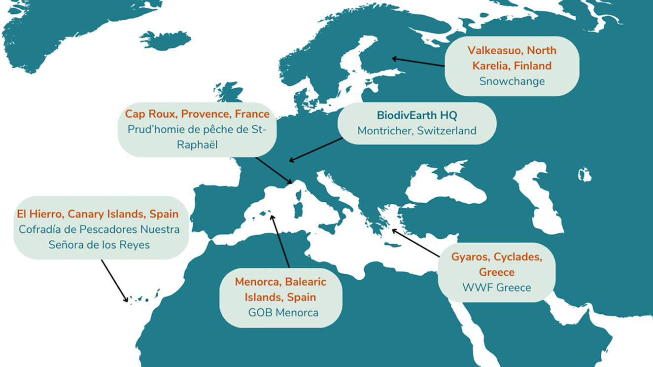
The case study is implemented through a community of practice (CoP) developed around a core group of pilot sites and integrating research organisations and regional and global initiatives. So far, five pilot sites have been selected for their long-standing success in conserving biodiversity and functional ecosystems while supporting the social dynamic, livelihood and cultural practices of local societies: Minorca (Balearic Islands, Spain), El Hierro (Canary Islands, Spain), Gyaros (Cyclades, Greece), Cap Roux (Provence, France), and Valkeasuo (North Karelia, Finland). Each site embodies a particular management model and exemplifies resilience in socio-ecological landscapes, revealing key ingredients that help understand it.
While the first pilot sites are located in continental and ultramarine Europe to support initial exchanges amongst sites and facilitate the setup of the CoP by BiodivEarth, itself located in Switzerland, efforts are already underway to recruit sites in other regions to achieve a global CoP membership.
Socio-economic and environmental characteristics of the areas including benefits and threats to human-nature relationships
The five selected pilot sites are diverse in geography, ecosystems and management types (Figure 1). Key criteria to select those sites were: high levels of biodiversity maintained over the last decade(s), effective management scheme delivered by solid implementing actors, and the existence of long-term socioecological datasets generated through decade(s) of research and monitoring.
Figure 1: Pilot sites of the CoP, Location and focal point organisation
These sites illustrate the diverse forms of SEPLS governance: from voluntary stewardship agreements (Minorca) to formal co-management (Gyaros), fisher-led mechanisms (El Hierro, Cap Roux) and NGO supported traditional management by local communities (Valkeasuo). Each of those models hold some keys of resilience. Identifying those ecological, social, economic, and governance dimensions of resilience will be one of the key results of the BiodivEarth project.
Minorca, Balearic Islands, Spain
Designated as a UNESCO Biosphere Reserve, Minorca is a rich mosaic of terrestrial and coastal ecosystems, including wetlands, and traditional agroecosystems shaped by centuries of farming. The intricate mosaic formed by the cultivated fields delimitated by their dry-stone walls and the stretches of Mediterranean ecosystems surrounding them, was one of the factors for the decisive declaration of the Island as a Reserve of the Biosphere.
On this site, the management model is defined as “Land stewardship for the conservation of an agroecological mosaic” and is sustained by the Custòdia Agrària program through the Balearic Group of Ornithology and Defense of Nature of Minorca known as GOB Minorca, an NGO founded in 1977.
Established in 2004, this model has contributed to the conservation of Minorca’s mosaic landscape and promoted environmentally and economically sustainable farming. Today, around 12% of Minorcan farms are part of the Land Stewardship network and 4% of Minorca’s total land area is under this agreement. The farmers themselves, together with GOB, act as stewards of the model. GOB supports farmers in strengthening resilience, both in their agricultural practices and in environmental and economic terms. The NGO also monitors key impacts, including ecological footprint, bioindicators, and carbon capture. Expanding the model to new farms and raising awareness through education are also central to GOB’s work. The model is based on voluntary agreements between farmers, landowners, and GOB, fostering collaboration for long-term sustainability.
The model enhances biodiversity and strengthens farmer incomes. Products from Land Stewardship farms show much lower ecological impacts: beef has a 60% smaller footprint, fruits and vegetables 66% less, and cured meats 71% less than the Spanish average, thanks to extensive grazing, fewer agrochemicals, and reduced external feed. Threats to human-nature relationships include pressures from tourism, land-use change and water scarcity, which threaten both biodiversity and traditional practices.
From 2009 to 2025, OBSAM (Socio-environmental Observatory of Minorca) carried out comprehensive biodiversity surveys covering 47 farms and 4,265 ha (about 6% of the island), resulting in yearly reports, scientific publications, and detailed ecological cartography.
El Hierro, Canary Islands, Spain
El Hierro, the smallest of the Canary Islands, is known for its community-based artisanal fishery, which has achieved remarkable sustainability. El Hierro is characterized by a very narrow continental shelf, oligotrophic waters, and fragile marine ecosystems. The island’s marine landscape, of an eminently volcanic nature, creates a wide variety of environments that support a rich and diverse flora and fauna, well preserved thanks to the absence of mass tourism and decades of fisheries management focused on environmental, social, and economic sustainability.
This integration of traditional knowledge with modern governance has produced a socio-ecological system where local fishers act as custodians of biodiversity while securing their livelihoods. The management scheme on this island can be termed a “Community-led management of natural resources”.
Since 1978, this model has promoted the protection of marine ecosystems while fostering economic, social, and environmental sustainability. Forty small-scale fishers, acting as stewards, are organized in a representative, consultative, and collaborative body known as the “Cofradía”, a governance model dating back to the 16th century. Through collective decision-making, El Hierro’s fishers manage marine resources sustainably, participate in fisheries monitoring with the scientific community, and implement self-regulation practices to protect both the resources and the seabed around the island. Notable measures that have been deployed include eliminating high-impact fishing gear and creating the “Punta de La Restinga–Mar de Las Calmas” Marine Reserve of Fishing Interest, as well as other agreements driven by the local fishing sector itself, such as increasing minimum catch sizes and establishing voluntary fishing closures.
This model has enabled the conservation of marine resources and the preservation of the fishers’ cultural identity and cohesion while contributing to the stabilization of economic income that supports the viability of their fishing activities Threats include generational renewal in the fishing community, competition with industrial fleets, illegal fishing and overexploitations, external pressures from climate change and pollution.
For over 40 years, the University of La Laguna, the Spanish Institute of Oceanography (IEO) and Pescaviable have empowered small-scale fishers in El Hierro with scientific insight, socio-economic support, marine-reserve planning, and practical management guidance.
Gyaros, Cyclades, Greece
Located in the Cyclades archipelago, Gyaros is an uninhabited island surrounded by a Marine Protected Area (MPA) that is home to one of the largest populations in the region and globally of the endangered Mediterranean monk seal (~70 individuals and 10 births/year). The island also hosts notable avifauna, including Mediterranean shearwaters (Puffinus yelkouan), Eleonora’s falcons (Falco eleonorae), and Bonelli’s eagles (Aquila fasciata), along with a variety of endemic plants and invertebrates. Its multiple benthic habitats cover 50% of the MPA and include Posidonia oceanica meadows, coralligenous formations, submerged and partially submerged sea caves, as well as steep seabed slopes. Gyaros is known for its exile prison and traces of ancient Roman civilization. Although uninhabited, tourists can visit the island through hiking and diving.
The management scheme in Gyaros is defined as a “Fishing No-Take Zone in MPA“.
Since 2013, this model is supporting habitat protection, biodiversity conservation and the recovery of fish stocks affected by fishing pressure. By reducing illegal activities within the MPA, it also aims to enhance catches in the surrounding fishing areas, adjacent to its 26,000hectare No-Take Zone (NTZ). The model also seeks to increase knowledge, enhance stakeholder awareness and engagement and to preserve social and cultural aspects. The MPA is supported by WWF Greece and is under the responsibility of the Greek Natural Environment and Climate Change Agency (NECCA). Key to the initial success of the management scheme was the establishment of a co-management committee comprised of representatives from ministries, local authorities, fishers and other area users, NGOs and research bodies. The model manages human activities, especially fisheries, through a no-take zone supported by a remote surveillance system, the regulation of maritime uses and anchoring control. It also focuses on monitoring the area’s natural environment and raising awareness among various stakeholders.
The model has contributed to significant biodiversity recovery, knowledge increase (over 55 studies and monitoring projects conducted) and habitat protection. It also led to a major reduction in illegal professional fishery (85%) and is positively perceived by most of the local fishers (78%) who report strengthened trust, increased cooperation, and greater recognition of cultural heritage. Threats include maintaining stakeholder engagement over time, securing long-term funding, and balancing conservation with emerging touristic interests.
Between 2018 and 2023, the Hellenic Centre for Marine Research (HCMR) has conducted experimental fishing surveys inside the MPA (37 visits and over 120 hauls), resulting in a thorough understanding of the area’s marine life and documenting a significant recovery of local fish populations.
Cap Roux, Provence, France
Cap Roux, part of the Esterel coastal area in southern France, is located on a densely populated and highly touristic coast. The environment is diverse: rocky seabed, Posidonia seagrass beds, and coralligenous reefs, which allow for a wide variety of fish to live, feed, and reproduce.
Cap Roux exemplifies the role of participatory conservation in reconciling ecological integrity with economic and recreational activities. This management model is a “Fishing No-Take Zone established by small scale fishers”.
Established in 2003, the Cap Roux Fishing Reserve model aims to preserve fish stocks to support artisanal fishing and protect marine habitats. The reserve was created by the Prud’homie of Saint-Raphaël, a traditional artisanal fishing management institution dating back to 1856 and bringing together 18 fishers. Prud’homies emerged in the early Middle Ages and the cofradías (see El Hierro’s management model) developed later in the medieval period. Both models reflect a continuity of traditional community-based management institutions. In Cap Roux’s model, other stakeholders are also involved, such as the city of Saint-Raphaël, the Esterel Côte d’Azur urban community and various NGOs. Within the 445-hectare protected zone, all forms of fishing are prohibited. The prud’homie fishers carry out experimental fishing to assess fish stocks. The Prud’homie of Saint Raphaël seeks to strengthen the coordination and communication between fishers, scientists, and local authorities to maintain the effectiveness of the fishing reserve and continue showcasing Cap Roux as a model of positive, locally driven sustainable use of resources that also supports marine conservation.
This model has led to an increase in overall fish biomass and in the size of individual fish inside the reserve. It has also contributed to the spill over of juvenile fish outside the fishing reserve into the fishing grounds. Challenges include ensuring compliance of restrictions within the no-take zone and balancing sustainable fishing objectives with increasing tourism demand throughout the perimeter managed by the Prud’homie.
Since 2003, the University of Nice (Ecoseas Laboratory) has led various monitoring activities in the no-take zone in collaboration with local fishers. Now the community aims to enhance data collection and ensure a coherent and collaborative monitoring of the fishing reserve.
Valkeasuo, North Karelia, Finland
Valkeasuo is a largely intact boreal peatland and forest mosaic that supports exceptionally rich biodiversity, including the region’s best nesting sites for bean geese (Anser fabalis), endangered golden eagles, other migratory birds, especially waders like godwits and is visited by large predators such as wolverine, lynx, wolf and brown bear. Valkeasuo’s mostly pristine condition and strong restoration potential make it a critical stronghold for thriving boreal ecosystems. This site’s management model is defined as an “NGO supported traditional management by local communities”.
Located in the Koitajoki Basin, Valkeasuo has benefited from its proximity to the Koivusuo Strict Nature Reserve (Finnish: luonnonpuisto), which has been an IUCN-protected area since 1982, as well as to other nearby protected areas, helping to preserve its biodiversity. Closed to the reserve and considered unsuitable for forestry use, the site remained de facto mostly undisturbed though without formal protection for decades. Today, around two-thirds of Valkeasuo are pristine, while one-third is degraded with strong restoration potential. Snowchange has owned the 450-ha area for two years, and all economic exploitation is prohibited. Through agreements with neighbouring landowners, including the Finnish state and Tornator forestry company, buffer zones have been secured and peatlands protected.
By integrating local knowledge, community participation, and strict ecological protection, the model aims to support peatland restoration, maintain intact ecosystems, and recognize traditional practices such as berry harvesting, which hold both ecological and cultural importance. The site also plays a major role as a headwaters ecosystem for streams and, ultimately, the Koitajoki River. It is located in the headwaters of the Kelsimä River, which is one of the major subcatchments of the Koitajoki system. Restoration activities have included restoring hydrological cycles, closing forestry ditches to raise water levels in affected areas, developing a management plan for impacted timber resources, assessing deciduous forest corridors along the Polttopuro stream that flows across the site, and identifying restoration potential for nutrient-rich letto peatlands, a critically endangered wetland type that is present on Valkeasuo at a small scale.
Through management agreements and the inclusion of local people, Snowchange was able to extend Valkeasuo’s conservation influence to 150 ha, bringing the total area under conservation influence to 600 ha. Valkeasuo represents an alternative to top-down and extractive land use, demonstrating that conservation can coexist with sustainable livelihoods and the long-term protection of natural and cultural values. Main threats to human-nature relationships in the general area around Valkeasuo, the Koitajoki River Basin, are resource extraction and rural depopulation. Threats to Valkeasuo include mining activities and exploration, as well as impacts from climate extremes, such as warming boreal habitats and extreme drought.
Monitoring in Valkeasuo combines long-term scientific data, including hydrological monitoring (aquatic indicators), remote sensing, habitat classification, greenhouse gas fluxes and assessments, as well as species records, with government research and Snowchange’s traditional knowledge–based ecological baselines.
Objective and rationale (including intended outcomes)
BiodivEarth aims to reinforce resilience in socioecological landscapes and seascapes. Working at the core of the Community of Practice it convenes, BiodivEarth seeks to better understand the keys to resilience in these Landscapes in order to develop a resilience diagnostic tool and strengthening kit. This initiative strengthens sustainable management models by supporting local stewards and promoting participatory approaches, with the aim of achieving durable and resilient conservation outcomes. Its vision is a world where human societies and nature thrive, nurturing one another in a respectful and sustainable manner. Its mission is to contribute to address the planetary crisis by accelerating existing efforts in conservation, restoration and successful sustainable resource use.
In its Community of Practice, BiodivEarth collaborates with a wide range of stewards that manage exemplary sites (indigenous peoples, local communities, farmers, fishers, foresters, landowners, entrepreneurs, protected area managers, and institutions). BiodivEarth identifies what enables some areas to maintain high biodiversity levels for over 20 years, working with pilot sites that exemplify resilient management systems. These pilot sites are initially based in continental and ultramarine Europe, with the perspective to expand globally. By involving these stewards in targeted research, BiodivEarth aims to identify key factors that make their management systems resilient.
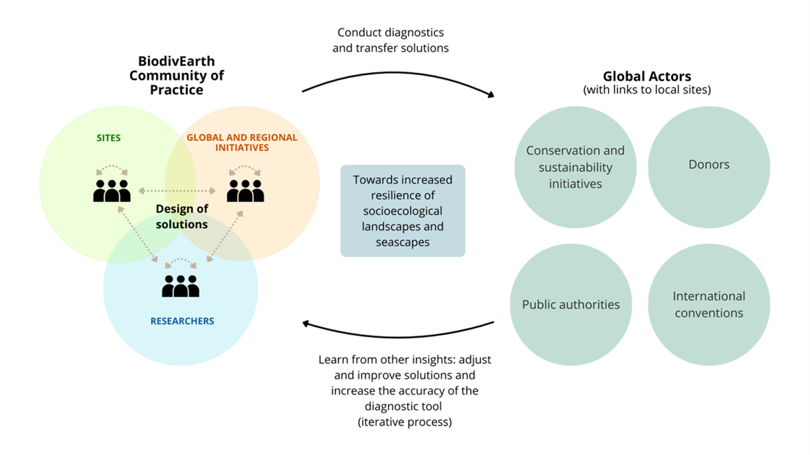
Overall, this community connects stewards, researchers, and global and regional conservation initiatives to exchange knowledge on resilience through peer exchange and collective learning. Partnerships with research institutions help identify key drivers of resilience, compare insights with other regions, and share findings broadly to strengthen resilience across landscapes worldwide (Figure 2).
Figure 2: Synergies between members
Intended outcomes of Phase 1 (concluding in September 2026):
- A range of solutions towards increased resilience is derived from know-how and research results.
- The resilience of pilot socioecological land and seascapes is reinforced through exchange of know-how and integration of research results.
- The CoP is operational, active, funded, and visible.
- The analysis of keys of resilience is completed, allowing for the development of a diagnostic tool in Phase 2 of the project.
Intended outcomes of Phase 2 (starting in September 2026):
- Grow the CoP by welcoming more sites from the current focal regions (Mediterranean, Macaronesia and Northern Europe), and by opening the CoP to other regions of the world and to different types and level of management (including less advanced sites). This expansion of the CoP will seek to deepen shared knowledge, increase the robustness of research analyses and associated predictions, and accelerate the transfer of learnings.
- Develop a diagnostic tool based on the results of analyses on keys of resilience and the consolidation of the knowledge and know-how extracted in Phase 1.
- Spread the use of the diagnostic tool to identify gaps in resilience and recommend solutions within and beyond the CoP through in-house expertise and collaboration with conservation initiatives and donors.
The project contributes to GBF Targets 3, 10, 21, and 22. It also aims at closely collaborating with IPSI on research aspects and as a platform for sharing practical solutions with IPSI members.
Description of activities and alignment with the Satoyama Initiative framework
Development of a Community of Practice
The project is developing a Community of Practice (CoP) that brings together the local stewards of pilot sites, national and international research institutions and conservation initiatives (Figure 3). Through the facilitation of this CoP, BiodivEarth seeks to foster the exchange of existing know-how and to stimulate the emergence of innovative solutions for strengthening the resilience of effectively managed socioecological landscapes and seascapes. It also acts as a cradle to collectively research the keys of resilient management. Overall, the CoP provides enhanced visibility to pilot models and promotes peer exchange and collective learning. Members meet in-person and online to define shared needs, exchange their proven solutions and identify resilience factors in their own land/seascapes (Figure 5). The CoP is formed by three pillars: Pilot site stewards, researchers studying sustainability and resilience, and global and regional conservation initiatives seeking the sustainability of their impact.
Figure 3: Representation of the current Community of Practice
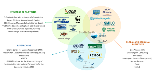
Pilot sites are managed landscapes or seascapes that have demonstrated long-term success in maintaining high biodiversity in functional ecosystems and balanced societies in socio-economic and cultural terms. They serve as living examples from which other local stewards can learn and be inspired. Pilot sites also provide case studies for the evidence-based research conducted through the CoP.
Global and regional initiatives encompass projects and organisations actively working on the ground and through policy to enhance biodiversity and promote sustainable management of natural resources in functional land/seascapes. They bring practical experience and innovative approaches that enrich the CoP and act as vortex for disseminating CoP learnings through their own networks.
Researchers include academic organisations and individuals interested in the study of resilient approaches to the management or conservation of natural resources and biodiversity by local stakeholders. These researchers contribute through scientific knowledge, provision of data and tools, and part-taking in analyses to understand how to strengthen resilience across land and seascapes within the CoP and globally.
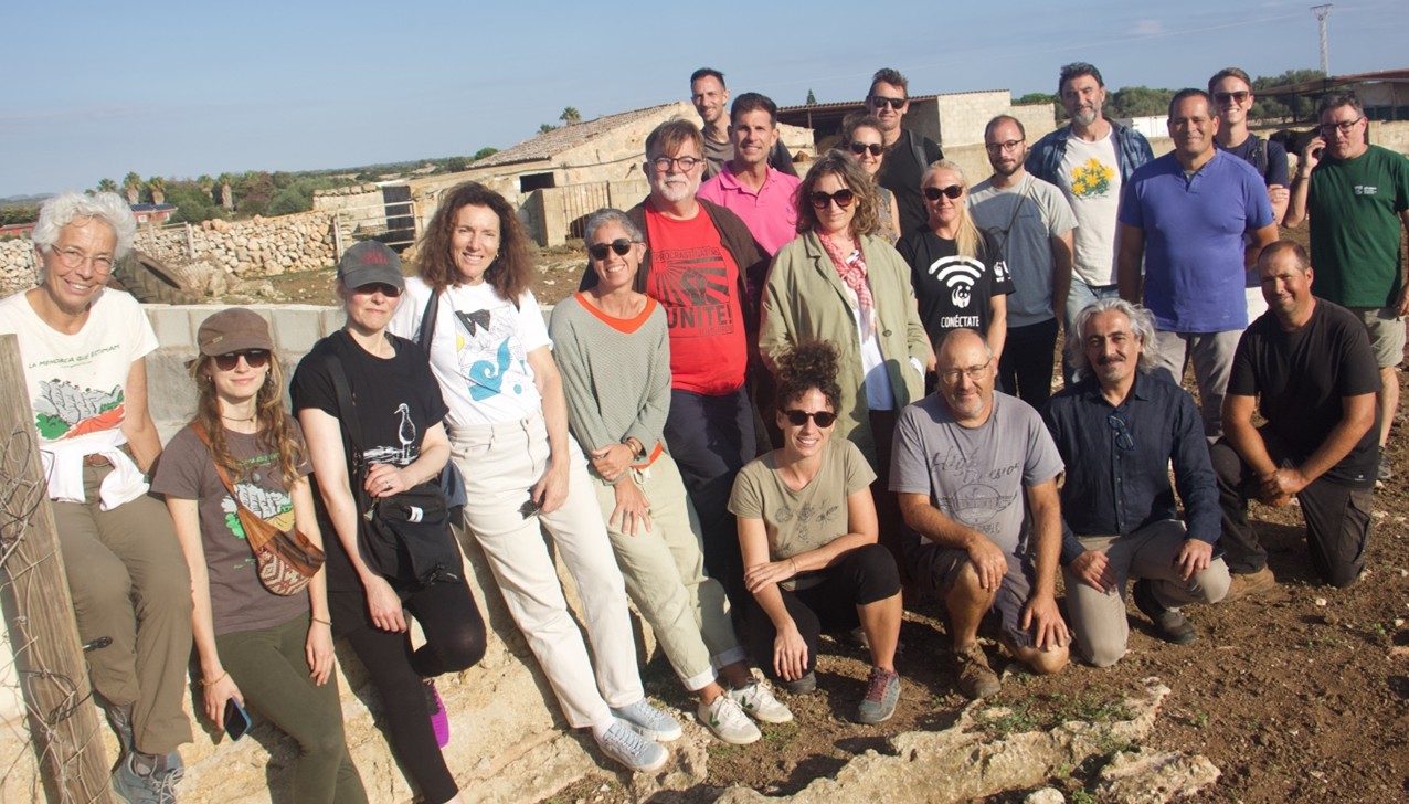
Figure 4: Meeting of stewards, researchers and global initiatives leaders in Minorca, October 2025
- This activity is aligned with the Satoyama Initiative framework, in particular: Exploring new forms of co-management systems or evolving frameworks of “commons” while respecting traditional communal land tenure; and with the perspective of: Multi-stakeholder participation and collaboration in multi-functional management of natural resources and ecosystem services.
Researching the factors of resilience
BiodivEarth research program focuses on understanding what makes socio-ecological seascapes and landscapes resilient. The work builds on five pilot sites (Minorca, Gyaros, Cap Roux, El Hierro, and Valkeasuo) that already demonstrate long-standing success in maintaining biodiversity and ecosystem functions while supporting local socio-economic and cultural dynamics. 15 sites worldwide are being added for analysis purposes. The research aims to provide an analysis of these successful models to determine if specific common characteristics, patterns or combination of factors emerge.
The research approach is structured in two phases:
- Phase 1 (2024–2026) involves identifying and testing key factors and variables that underpin resilience through self-assessment methods (semi-quantitative), and comparative quantitative analyses across the pilot sites and an additional 15 sites worldwide. In addition, a dynamic model will be developed to help balancing factors affecting resilience. Actionable versions of this model will be delivered for each of the pilot sites.
- Phase 2 will develop a diagnostic tool meant to be run in any socioecological landscape or seascape with the intention to assess gaps in resilience and to propose possible solutions derived from the experience and know-how of the stewards of the CoP. The power of the diagnostic tool – accuracy and precision – will increase in an iterative manner with the data brought by each new site joining the CoP. The second major research objective in Phase 2 will be to move from a single-site to a multiple-site diagnostic tool, allowing assessment and monitoring of resilience across larger areas, such as the various sites of a conservation initiative or of a donor’s portfolio. Such tool will offer a systematic and field-grounded method to monitor progress regarding resilience towards global conservation and sustainable development targets. It will also provide a reliable mean to guide sustainability-conscious investment.
To this end, BiodivEarth is partnering with local and global research institutions (UNU-IAS / IPSI Secretariat, RESTOR, OBSAM, HCMR, Pescaviable etc.).
- This activity is aligned with the Satoyama Initiative framework, in particular: Consolidating wisdom on securing diverse ecosystem services and values, and integrating traditional ecological knowledge and modern science to promote innovations.
Dissemination of the project results
Through regional and global conservation initiatives and by directly promoting the use of the developed tools, BiodivEarth will share the findings from the research component of this project. In Phase 2 of the project, BiodivEarth plans to develop a set of services to operate the diagnostic tool and to adapt solutions locally to enhance resilience in land and seascapes outside the CoP worldwide.
- This activity is aligned with the Satoyama Initiative framework, in particular the perspective related to: Improved community resilience to achieve multiple benefits through ecosystem-based approaches.
e) Results and lessons learned
Although BiodivEarth is still working with its CoP to determine the factors enabling resilience in the pilot landscapes and seascapes, some preliminary elements have been identified. So far, those elements are organised within a framework of descriptors organised under three general dimensions: Strategy and management, Enabling conditions, and Governance (Figure 5). Here is a scheme representing those elements, extracted from preliminary inputs given by the pilot sites stewards and site-related researchers.
Figure 5: Resilience Factors
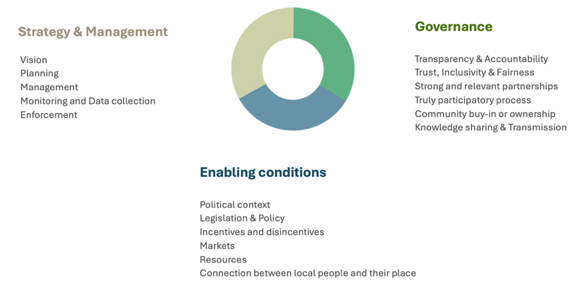
This framework was used to capture what the stewards of each site perceived as the main factors that have contributed to the long-time success of their site.
Resilience factors identified in Minorca
In terms of strategy and management, Minorca’s long-term vision and its integration of traditional and scientific knowledge appear to have contributed significantly to its success. Regarding enabling conditions, the introduction of the landuse policy known as the Insular Territorial Plan (PTI) and the Biosphere Reserve Action Plan helped limit urban pressure, providing supportive legislation and facilitating the development of the land stewardship model. Concerning governance, long-term and inclusive relationships with farmers, a strong community on the island, as well as GOB’s independence from political influence appear to strengthen the system’s resilience.
Resilience factors identified in El Hierro
For El Hierro, strategic and management factors include the involvement of fishers in planning and a self-regulated enforcement system, both of which appear to support the model’s success. Enabling conditions include market mechanisms such as direct commercialization by fishers, allowing them to set fair prices. In terms of governance, teamwork and a non-competitive climate among fishers, strong ties between fishers and the wider community, and joint community planning all emerge as resilience factors. The model highlights that ensuring resource managers can make a viable living from their work is essential.
Resilience factors identified in Cap Roux
In Cap Roux, the Prud’homie’s long-term strategic vision permitted to mature the idea of a No-Take Zone (NTZ) and, in due time, adopt it consensually. Enabling conditions include supportive legislation, notably the national-level legal recognition of the NTZ. Amongst the governance factors contributing to resilience, the participatory process embodied by joint decision-making within the Prud’homie stands out.
Resilience factors identified in Gyaros
In Gyaros, strategic and management strengths include the clear vision provided by WWF for a NTZ model adapted to the Greek national context, robust monitoring and data collection, and an effective, tailor-made surveillance system. Governance resilience was supported by participatory processes such as a co-management committee and the transmission of knowledge to decision-makers and enabling adaptive management.
Resilience factors identified in Valkeasuo
Under evaluation.
Key messages
As illustrated in the self-assessments by the stewards from our pilot landscapes:
- Strong, legitimate, and locally rooted governance appears to be the cornerstone of long-term resilience.
- A shared long-term vision developed and carried by the main stewards of a landscape is a mandatory catalyser around which resilience can grow. Additionally, there needs to be a concrete and durable platform (for example local management committees or sectoral bodies) to support the development and application of such vision.
- Locally adapted technical knowledge, effective monitoring, data-driven decision-making, and adaptive management are critical for durable conservation outcomes.
- In Landscapes where the stewards are primary producers, it is essential to ensure that they can make a viable living from their work.
References and bibliography
Minorca:
https://www.menorcabiosfera.org/contingut.aspx?idpub=2764
https://www.gobmenorca.com/custodia-agraria/
El Hierro:
https://wwfes.awsassets.panda.org/downloads/ElHierroPNM1.pdf
https://reservabiosferaelhierro.com/wwf-se-interesa-por-la-pesca-sostenible-de-el-hierro/
Gyaros:
https://www.wwf.gr/en/our_work/nature/marine/marine_protected_areas/gyaros/
Impact assessment: https://wwfeu.awsassets.panda.org/downloads/gyaros_mpa_impact_assessement_repor_wwf_greece_12_2025.pdf
Cap Roux:
https://esterel.n2000.fr/sites/esterel.n2000.fr/files/documents/page/cap_roux.pdf
https://esterel.n2000.fr/site-natura-2000-de-l-esterel
Snowchange:
https://www.snowchange.org/2023/11/home-of-the-bean-geese-valkeasuo-peatland-and-advancements-over-1000-hectares-crown-the-rewilding-autumn/
https://rewildingeurope.com/rew-project/koitajoki-basin/
Figures, tables and photos: included within the main body text, with captions and credits as appropriate
Figure 1: Pilot sites of the CoP, Location and focal point organisation, BiodivEarth original production, 2025
Figure 2: Synergies between members, BiodivEarth original production, 2025
Figure 3: Representation of the current Community of Practice, BiodivEarth original production, 2025
Figure 4: Meeting of stewards, researchers and global initiatives leaders in Minorca, October 2025, ©Tanis Jacques, 2025
Figure 5: Resilience Factors, BiodivEarth original production, 2025
Web links of any relevant organizations and projects
Main organization website:
- BiodivEarth: https://biodivearth.org/
BiodivEarth relevant links:
- Video briefly presenting the project https://biodivearth.org/wp-content/uploads/2025/02/Biodivearth_ssLogos_4K.mp4
- BiodivEarth presented by its board members https://biodivearth.org/wp-content/uploads/2024/10/VF-video-Board.mp4?_=1
Pilot sites websites:
- Cap Roux, Prud’homie de Saint-Raphaël : https://www.planetemer.org/actions/cap-roux
https://www.saint-raphael.com/fr/saint-raphael/mer/sites-proteges/133-le-cap-roux
- GOB Minorca: https://english.gobmenorca.com/
- Gyaros: WWF Greece: https://www.wwf.gr/en/our_work/nature/marine/marine_protected_areas/gyaros/
- Pesca Restinga: https://pescarestinga.es/
- Snowchange: https://www.snowchange.org/
Conservation Initiative websites:
- Blue Alliance Marine Protected Areas: https://bluealliance.earth/
- Blue Pangolin: https://www.blue-pangolin.net/
- Blue Seeds: https://blueseeds.org/en/
- LIFE (Low Impact Fishers of Europe): https://lifeplatform.eu
- Nature Returns: https://nature-returns.eu/
- SMILO: https://smilo-program.org/fr/
- Yolda initiative: https://yolda.org.tr/
Research websites:
- HCMR: https://www.hcmr.gr/en/
- OBSAM: https://www.obsam.cat/
- Pescaviable: https://www.pescaviable.com/
- RESTOR: https://restor.eco/
- UNU-IAS: https://unu.edu/ias
Author's profiles
Dr. Paule Gros holds a PhD in Conservation Biology from the University of California, Davis. She previously led UNESCO’s project on Mayangna knowledge of freshwater systems and later served as Head of Strategic Partnerships and Mediterranean Program Director at the MAVA Foundation. She is now Co-founder and CEO of BiodivEarth.
Mrs. Marie Romani holds a Master’s degree in Water Management from AgroParisTech and an engineer diploma from SeaTech. She served as Executive Secretary of MedPAN, the network of Mediterranean Marine Protected Areas for nearly 15 years. She is currently the Network Coordination Manager at BiodivEarth.
Mrs. Adeline Schwab holds a Master’s degree in Responsible Management from the University of Geneva. After gaining experience in non-profit project management and in Indigenous Peoples Preservation through Tchendukua Suisse, she is now the Project Support and Communication Manager at BiodivEarth.
Mrs Tanis Jacques holds a Master’s in Responsible Management from the University of Geneva. After her experience as Project Development and Communication Manager at BiodivEarth, she is now working at B Lab Switzerland as Certification and Impact Coordinator.
Dr. Jonathan Peereman holds a PhD in Forest Ecology from National Taiwan Normal University. He worked in botanic gardens in South-East Asia before conducting research on forest resistance and conservation in Taiwan, and on agroecological landscapes at the University of Liège. He oversees the research component at BiodivEarth.